


The first launch version of the Glúnta Church Map is now finished and ready for launch on the 29th May.
That sentence feels very strange to write, because there is a fair bit of caveating still to come. Over the past while I have been gathering, checking, organising, correcting, and mapping publicly available information on evangelical and Protestant church presence across the Republic of Ireland. As I’ve explained in previous posts, this has meant scanning through church websites, denominational directories, public social media pages, meeting locations, Eircodes, coordinates, affiliations, and all the slightly awkward details that come with trying to figure out if a church is still active, changed it’s name, or has now become a online gardening store (I kid you not!)
I wanted to put out some posts before the launch to talk about what the map is, what is does, and then explain how to use it. Then on the 29th you can play about with it to your heart’s content. If, like me, scrolling through maps and church locations is your cup of tea!
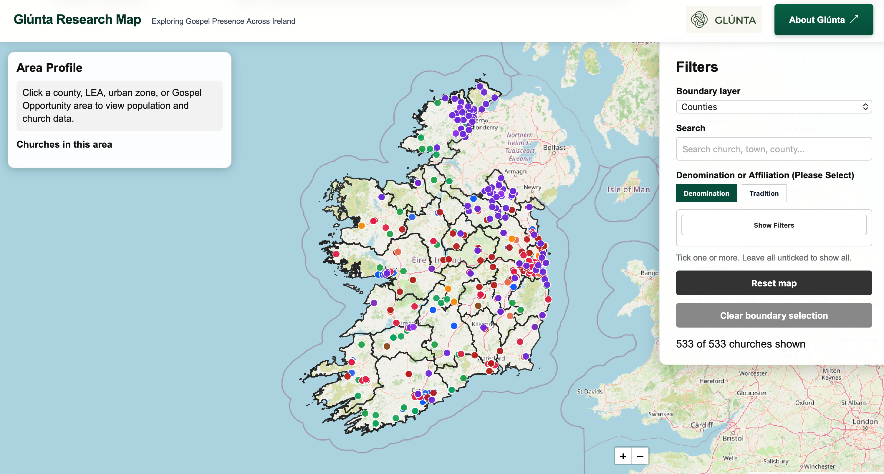
The first and most basic function of the map is also the most important. It basically shows where churches are currently listed as meeting in Ireland.
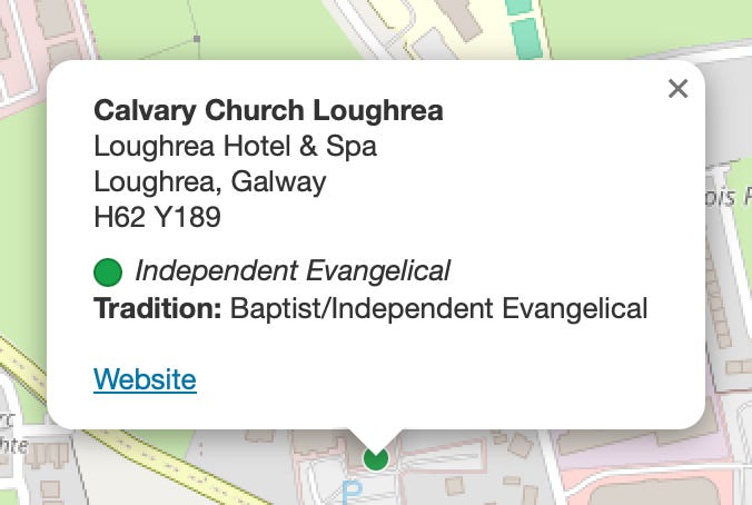
That may sound obvious. In one sense, it very much is. A church map begins with church markers. We’ve perhaps all seen them on denominational websites and reports. Each marker represents a gathered congregation, a public meeting place, a local body of believers. Click on a marker and you can see basic public information such as the church name, location, county, denomination or affiliation, and website where available. As I’ve mentioned before, I am not listing anything private or gathering personal information. It is simply trying to make visible what is already public, but often scattered across the internet on various sites, and then visualising it in a way that enables us to interpret what it means.
This is the bit that I envisioned before I started, and as I laid out in the last post, why I decided to code the map myself. It allowed me to make the map fully interactive in a way that lets me (and us) see all these churches in their various affiliations on one central map. Once that happened and I zoomed out, I got to see something very interesting. Some places have clusters. Some have large spaces between them. Some towns look well served at first glance, while other areas are surprisingly underserved. A dot may represent a congregation with long history, strong leadership, and deep roots. Another dot may represent a small group of believers meeting faithfully for only a few months. The marker itself cannot tell the whole story, but it does give us a place to begin. I am not at present, looking to map on church data because I need a break from spreadsheets! But perhaps in the future. And also because the guys at Evangelical Alliance Ireland hope to redo and update their research study from 2018. Keep an eye out for that!
However, before we can ask deeper questions about mission, we need to ask the basic geographical question: where is visible Gospel witness currently gathered?
Over this past few months I have had a number of conversations with friends about how we understand where churches are, and what I have realised is that our assumptions are often shaped by familiarity. We know the churches in our own network and tribe. We know the towns we drive through or live near. We know the places we have visited, preached in, partnered with, or heard stories about. But Ireland is bigger than our relational map. A pastor in Galway may have a reasonable instinct for the west, but much less clarity about the midlands. A church in Dublin may know its own part of the city well, but not necessarily the towns beyond the commuter belt, beyond the Pale if you will. A denomination may understand its own distribution, but not how that sits alongside the wider evangelical picture. Someone from another country, who desires to partner with an Irish church might only have a small glimpse of the wider needs on the island.
A map does not fix that problem, but it helps put the question in front of us to begin to chip away at. But it also does something that I’m looking forward to. It actually slows us down.
If you have conversations about evangelism, mission, church planting etc. you will probably realising that this type of talk can become abstract very quickly. We speak about reaching Ireland, planting churches, strengthening Gospel witness, or seeing renewal and revival across the nation. Those are good desires, but they need the discipline of place. Which towns? Which communities? Which rural areas? Which growing commuter settlements? Which parts of the country have visible church presence, and which parts appear less served?
My hope is that they Glúnta Church Map begins there, with the simple work of locating churches. And then we go from there…
Of course, this first launch version is not a perfect final word. It cannot be. Some details will need corrected. I sincerely hope not a lot! Some churches may be missing. Some meeting locations may have changed. Some websites may be out of date. Public data is useful, but it is never flawless. I have stared cross-eyed at spreadsheets for quite a while now. I’ve also had a lot of help! (Shout out Laura, Duncan, and Stephen!) I’ve had e-mails with guys in the Methodist Church in Ireland. The Baptist Association of Ireland sent me their directory of churches which was such a help. I had a very encouraging conversation with Nick Park from the Evangelical Alliance. The map isn’t even out yet, but the shoots of collaboration are already really exciting!
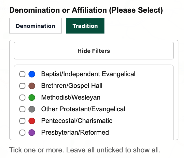
So…. the map should be read as a starting point, and with a bit of grace. It is something to be reviewed, improved, corrected, and strengthened over time. There will also be things that you’ll scratch your head over. One of which is categorisation. I found over 500 churches, and around 250-300 different categorisations and nuances of tradition. I’ve made some adjustments to try to streamline this. If your church has been mislabelled or you’d like more clarification, please reach out. The map isn’t perfect, because I’m not perfect. But, as I said, I hope to collaborate to see it become more reflective as we go on.
Still, finishing this first launch version feels significant.
Not because the map answers every question (it won’t), but because it helps us ask better ones (I hope it does!). It allows us to move from vague awareness to more visible patterns. It gives churches, planters, networks, and mission partners a shared tool for prayer, conversation, and planning.
Over the next two weeks, before the full public launch on Friday 29 May, I’ll be sharing a few of the main features of the map and what they are designed to help us see.
For now, the starting point is simple.
Where is visible Gospel witness currently gathered in the Republic of Ireland?
That question is now on a map.